Dream Kayak Catch, Dorado on the Rocks and Full Conditions Update
Dream Kayak Catch, Dorado on the Rocks and Full Conditions Updates: What another day! What a week. Everyone is smiling, even and especially the divers. As they pull some magic out of the bag yesterday and today. Amazing catches and underwater experiences. We gonna have to wait for The Bear to deliver his action-packed Master Watermen Friday Report tomorrow at around 4pm.
Enjoy today’s AM Roundup…
Dream Kayak Catch
Martin deJager made the BOMB of a catch off his kayak on the KZN South Coast day before yesterday. Aside from the first couta of the season caught on the KZN south coast, Martin also bagged a bus GT. Looks over the 20kg mark to me from this angle.
But that’s not all…!
Check at all the dorado lying on the floor! Plus an angry looking skipjack tuna (call it what you like). What a dream catch for anyone.
Dorado on the Rocks
Should read dorado off the rocks this morning at the Margate Pier. Tom caught one on a live shad earlier. And then a little later on a top bung bait, Koos got one too! A monster of a fight, koos lasted a full 90 minutes before someone went down and grabbed the fish for him.
Synoptic Analysis
Looks good for the next few days. A cold front with a slightly more serious face is aiming for Cape Town. To be there in about three or four days and then us later next week.
But for right now, and for this weekend, if you can get out there, go for it!
And we never even said shad once!
Sardines and Sighting Maps
It has been a fantastic sardine run this memorable 2024. And all the action has been logged right here on The Sardine News. This year’s map has been viewed 195,000 times and just keeps growing.
Which led us to decide to keep the map live. And keep adding unique marine animal sightings and events. That occurs non-stop all year round. This year we started to log more whale and dolphin sightings. And we even had a shipwreck! And a freaking tornado! And recently a capsized KZNSB boat! We have been updating the map with recent catches too…
These events will from now on be included in the Sardine News Sightings Map for 2024. And on the 1 January 2025, we shall start all over again.
Here are the links to existing and past Sardine Sighting Maps. Great for a windy day like today to research. With instructions to install The Sardine News right on your phone or desktop.
Freshly Minted Perfect Ocean Report by The Bear 3 Dec 2024
Freshly Minted Perfect Ocean Report by The Bear 3 Dec 2024: The Bear fires up our daily collection of reports and news items. Starting from the beach down the KZN South Coast, with this viz report and overall look at the perfect sea today.
Make use of the daily data set presented as a heads-up display on each and every report.
Thanks, Bear!
Umhlanga
A sneak peak at early Umhlanga this morning…
Conditions Update by Sean Lange
Good times ahead!
Tuesday Afternoon Dive Report
The Bear checks in AGAIN this unforgettable Tuesday…
Sardines and Sighting Maps
It has been a fantastic sardine run this memorable 2024. And all the action has been logged right here on The Sardine News. This year’s map has been viewed 195,000 times and just keeps growing.
Which led us to decide to keep the map live. And keep adding unique marine animal sightings and events. That occurs non-stop all year round. This year we started to log more whale and dolphin sightings. And we even had a shipwreck! And a freaking tornado! And recently a capsized KZNSB boat! We have been updating the map with recent catches too…
These events will from now on be included in the Sardine News Sightings Map for 2024. And on the 1 January 2025, we shall start all over again.
Here are the links to existing and past Sardine Sighting Maps. Great for a windy day like today to research. With instructions to install The Sardine News right on your phone or desktop.
Weather forecasting has become a sophisticated science, thanks to advanced weather models. However, the accuracy of these models can vary, leading to different forecasts from services like Windguru, Windy, the South African Weather Service (SAWS), and Tides 4 Fishing.
Choose your Weather Forecasting Model Carefully
Windguru: Windguru is popular among wind sports enthusiasts for its detailed wind forecasts. It uses models like the Global Forecast System (GFS), Weather Research and Forecasting (WRF), and the High-Resolution Limited Area Model (HIRLAM). While these models provide valuable data, their predictions can sometimes differ, causing confusion for users.
Windy: Windy offers a visually appealing platform with multiple weather models, including the European Centre for Medium-Range Weather Forecasts (ECMWF), GFS, ICON, and NAM. The ability to switch between models is useful, but it also highlights the discrepancies between them. Users often find themselves comparing forecasts to get a more accurate picture.
South African Weather Service (SAWS): SAWS relies on the Unified Model, developed with the UK Met Office. This model provides high-resolution forecasts for Southern Africa. Despite its sophistication, the Unified Model’s predictions can still vary from other models, leading to different weather outlooks.
But like ANY ANC-led government service, this is today’s screen…
Not a very good weather forecasting model at all
And so I got the synoptic chart image from Kobus Botha’s Weather Photos page. An absolutely brilliant piece of portal work gathering all kinds of weather imagery and chart data,
Tides 4 Fishinhttps://tides4fishing.comg: Tides 4 Fishing combines tidal data with weather forecasts from models like GFS and ECMWF. While this blend is useful for anglers, the varying predictions from different models can make it challenging to plan fishing trips accurately.
The Synoptic Chart Advantage: Given the inconsistencies between weather models, a good old synoptic chart can often be more reliable, especially when combined with local knowledge and experience. Synoptic charts provide a broad overview of weather systems, helping to identify patterns and trends that models might miss. Local knowledge adds another layer of accuracy, as residents understand the nuances of their region’s weather.
This is NOT from SAWS. This is from Kobus Botha Weather – a fantastic site to gain your own perspectives and insights.
In conclusion, while advanced weather models offer valuable insights, they can produce different forecasts, leading to uncertainty. A synoptic chart, mixed with local expertise, remains a powerful tool for accurate weather prediction.
Weather Forecasting Models
Global Forecast System (GFS): Developed by the National Centers for Environmental Prediction (NCEP) in the United States, GFS is a widely used global weather model that provides forecasts up to two weeks in advance.
European Centre for Medium-Range Weather Forecasts (ECMWF): Known for its high accuracy, ECMWF provides detailed medium-range forecasts up to two weeks ahead and is renowned for its ensemble prediction system.
ICON (Icosahedral Nonhydrostatic): Developed by the German Weather Service (DWD), ICON is a global model that offers high-resolution forecasts and is used for both weather and climate predictions.
UK Met Office Unified Model (UKMO): This model provides high-resolution forecasts for the UK and surrounding regions and is known for its accuracy in predicting severe weather events.
High-Resolution Rapid Refresh (HRRR): A short-term, high-resolution model used primarily in the United States for predicting severe weather events.
North American Mesoscale (NAM): A regional model that provides short-range forecasts for North America, focusing on severe weather and mesoscale phenomena.
Global Environmental Multiscale Model (GEM): Developed by Environment Canada, GEM provides high-resolution forecasts for Canada and the surrounding regions.
ARPEGE: A global model developed by Météo-France, ARPEGE provides medium-range forecasts and is known for its high-resolution output.
Ocean Forecasting Models
HYCOM (Hybrid Coordinate Ocean Model): Used by the U.S. Navy, HYCOM provides global ocean forecasts and is known for its high-resolution and accurate predictions.
NEMO (Nucleus for European Modelling of the Ocean): A widely used ocean model that provides forecasts for various regions, including the Arctic and North Atlantic.
OceanMAPS: Developed by the Australian Bureau of Meteorology, this model provides high-resolution ocean forecasts for the Australian region.
ECCO (Estimating the Circulation and Climate of the Ocean): A global ocean data assimilation system that provides high-resolution ocean forecasts and reanalyses.
BRAN (Bluelink Reanalysis): An ocean model developed by the Australian Government, providing high-resolution forecasts for the Australian region.
FOAM (Forecasting Ocean Assimilation Model): Developed by the UK Met Office, FOAM provides high-resolution ocean forecasts for the North Atlantic, Indian Ocean, and Mediterranean.
These models are crucial for accurate weather and ocean forecasting, helping us plan our activities, prepare for severe weather events, and understand the dynamics of our planet. While each model has its strengths, combining their outputs with local knowledge and experience can provide the most reliable forecasts.
: Meteosource : Meteologix : National Weather Service : Ocean Predict : Ocean Predict
What you really have to watch out for, however, is that people are 10 to 100 times more inclined to click on a weather warning than a normal post. So as an advertising medium that earns money from clicks, it would be tempting to say the least, not to post any good news. To choose the model that suits your sinister cash driven motivations. Keep them coming back by posting bad weather news.
This has been happening and has been wreaking havoc with travel bookings worldwide.
Everybody out to make a buck!
Sardines and Sighting Maps
It has been a fantastic sardine run this memorable 2024. And all the action has been logged right here on The Sardine News. This year’s map has been viewed 195,000 times and just keeps growing.
Which led us to decide to keep the map live. And keep adding unique marine animal sightings and events. That occurs non-stop all year round. This year we started to log more whale and dolphin sightings. And we even had a shipwreck! And a freaking tornado! And recently a capsized KZNSB boat! We have been updating the map with recent catches too…
These events will from now on be included in the Sardine News Sightings Map for 2024. And on the 1 January 2025, we shall start all over again.
Here are the links to existing and past Sardine Sighting Maps. Great for a windy day like today to research. With instructions to install The Sardine News right on your phone or desktop.
And The Shad Have Gone Mad again in KZN 2 December 2024
And The Shad Have Gone Mad again in KZN 2 December 2024: Sugar pocket size! These are big shad coming out at a few spots in KZN at the moment. Luckily they waited until now to start biting. Now that the shad season is officially open, that is.
Shad Kit
If you are looking to kit out for the shad in KZN this season, Township Hyper in Durban have all the goods. And at prices that make any visit worthwhile. You can take a peek at some items on their Facebook Page. But most real deals are in-store and on a strictly limited first-come-first-served basis.
Heading south…
Garrick in Margate
Margate Pier is still hosting visiting garrick. Although they are most certainly on their way south by now, you gonna get those tail-enders. Mainly though, the water is still quite clean.
Kob
Kob don’t mind the brown water at all. These guys, along with the shad, will be staple target species through December.
Umhlanga in the Morning
Umhlanga this very morning…
Synoptic Analysis
Well, we look fine for now but that little gathering of low-pressure systems hovering over the south-Atlantic should pique everyone’s interest. There is also a concentration of lows over the land and to the east. This is the kind of stuff you need to keep your eye on. This is a very interesting set of variables on their way.
Surfing
Waves for the weekend hopefully, no guarantees. Maybe tomorrow?
Diving
Very quiet under the water. A bit foggy for the spearos.
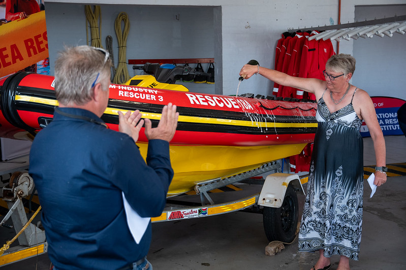
And finally…cool launch at Umhlanga yesterday…
Sardines and Sighting Maps
It has been a fantastic sardine run this memorable 2024. And all the action has been logged right here on The Sardine News. This year’s map has been viewed 195,000 times and just keeps growing.
Which led us to decide to keep the map live. And keep adding unique marine animal sightings and events. That occurs non-stop all year round. This year we started to log more whale and dolphin sightings. And we even had a shipwreck! And a freaking tornado! And recently a capsized KZNSB boat! We have been updating the map with recent catches too…
These events will from now on be included in the Sardine News Sightings Map for 2024. And on the 1 January 2025, we shall start all over again.
Here are the links to existing and past Sardine Sighting Maps. Great for a windy day like today to research. With instructions to install The Sardine News right on your phone or desktop.
NSRI Celebrates the Success of Pink Rescue Buoy Project
NSRI Celebrates the Success of Pink Rescue Buoy Project: as the 200th person we know of has been rescued using a Pink Buoy.
The National Sea Rescue Institute (NSRI) is proud to announce the ongoing success of its Pink Rescue Buoy initiative, which, since its launch in 2017, has been used to rescue more than 200 people – that we know of.
“The rescue of a young man and his father from a rip current at the Clovelly corner of Fish Hoek beach on Saturday, using a body board and Pink Rescue Buoy, marks the 200th successful rescue of a person in danger of drowning that we know of,” said NSRI CEO Mike Vonk.
”Mrs Gerna Conradie sponsored the Pink Buoy used in this rescue in the names of her grandchildren Grace and Daniel Tippet in April 2022. They were on the beach when the Pink Buoy was put in place, making it extra special for us to call Mrs Conradie to tell her that her Pink Buoy had saved a life,” he added.
“We are thrilled with the 200 lives we know have been saved using a Pink Buoy so far, underscoring the importance of readily making them available at high-risk locations.”
“The Pink Rescue Buoy project has been a game-changer regarding community involvement in water safety. Each Pink Buoy serves as a symbol of safety, provides a lifeline to those in distress and raises awareness about the dangers of water,” said Vonk.
The Pink Rescue Buoy project was launched to provide a simple, easy-to-use rescue device at popular yet sometimes dangerous swimming spots. These Pink Buoys, easily visible from afar, are positioned at beaches, rivers, and dams. They empower bystanders to act safely and quickly in an emergency, get the correct emergency number from the Pink Buoy sign, and ensure that assistance is available to the person in distress while awaiting formal rescue services.
NSRI’s Communications Manager, Andrew Ingram, emphasised the importance of public awareness and the role of untrained people in the initiative’s success: “The Pink Rescue Buoy is effective because it enables ordinary people to make a difference. Time is critical in any drowning situation, and having these buoys available means that anyone nearby can assist without putting themselves in unnecessary danger. We’ve seen numerous instances where, thanks to a Pink Rescue Buoy, lives that might otherwise have been lost have been saved.
“The Pink Buoys create awareness of water safety, as well as encourage communities to treasure and protect the rescue buoys that have been donated to their communities,” said Ingram.
Ingram further emphasised the importance of community involvement: “The success of the Pink Rescue Buoy project, however, depends on our communities. Without communities standing behind the project and teaching children that the Pink Rescue Buoys should not be taken off their poles except in an emergency, we will be unable to save lives.”
Vonk added: “Hundreds of drownings in South Africa each year are preventable if proper education and the right equipment were at hand. With the deployment of hundreds of Pink Rescue Buoys across South Africa, we hope these life-saving buoys will save lives on South African waters this summer season and for years to come.” The Pink Rescue Buoy project and the NSRI’s Water Safety Education and Survival Swimming programs form part of a comprehensive approach to water safety that relies heavily on community engagement. The NSRI’s efforts encourage communities to take responsibility for their local water environments, reduce risks, and ensure that safety is a shared priority.
“We cannot do this alone,” said Ingram. “The community plays a critical role in helping us prevent drownings. Whether it’s a member of the public using a Pink Rescue Buoy to save a life or someone passing on water safety knowledge to a child, every action counts. These collective efforts are what make our programs successful.”
The NSRI also urges community members to become “Pink Rescue Buoy volunteers” by reporting any missing Pink Rescue Buoys to the NSRI on 021 434 4011.
“Your report could save a life,” said Ingram.
The NSRI is committed to expanding the reach of its drowning prevention projects, ensuring that more communities have access to lifesaving tools and education. To this end, the organisation is continually seeking partnerships with local authorities, schools, and businesses to extend the network of Pink Rescue Buoys and increase the scope of its educational initiatives.
“Our vision is of a water-safe nation where drownings are significantly reduced,” Vonk stated. “We are making progress, but much work still needs to be done. By expanding our reach and focusing on education and accessible rescue equipment, we can save even more lives.”
The NSRI encourages the public to support its initiatives by spreading awareness, donating, or getting involved in local water safety programs. Every contribution, no matter how small, helps ensure that people of all ages can enjoy water activities safely.
Sponsor a Pink Rescue Buoy here https://shop.searescue.org.za/collections/accessories/products/pink-torpedo-buoy-lite-version or support the NSRI by donating on our website: https://www.nsri.org.za/support-us/donate
Media:
A picture of Grace Tippett with the Pink Buoy that was used in the rescue is available for download on NSRI’s Flickr page https://www.flickr.com/photos/searescue/54176770399/in/album-72157666055306218
Pink Rescue Buoy Key Metrics:
200 people we know of were rescued with a Pink Buoy 151 adults we know of were rescued with a Pink Buoy 49 children we know of were rescued with a Pink Buoy 127 males we know of were rescued with a Pink Buoy 56 females we know of were rescued with a Pink Buoy 165 casualties who needed a Pink Buoy 32 rescuers who needed the Pink Buoy
130 people, in 100 instances, needed the Pink Buoy because of rip currents
26 of the rescuers who used the Pink Buoy had training to perform this type of rescue.
For interviews or information, please get in touch with NSRI Communications Manager Andrew Ingram at andrewi@searescue.org.za or on 082 990 5977
ABOUT THE NSRI
The National Sea Rescue Institute (NSRI) is a registered non-profit organisation that is committed to drowning prevention and focused on saving lives, changing lives and creating futures for those threatened by drowning in South Africa.
The NSRI is unique in South Africa as the only non-profit organisation focusing exclusively on safeguarding lives and livelihoods in South African waters through education, prevention, and rescue operations. We envision a nation where drowning incidents are minimised, ensuring the safety of all.
The NSRI strives to innovate and evolve constantly and extend its water safety initiatives through empowerment and visibility. Our volunteers are on call 24/7 and rely on donations and sponsorships.
Please visit www.nsri.org.za for more information.
NSRI EMERGENCY: 087 094 9774
Sardines and Sighting Maps
It has been a fantastic sardine run this memorable 2024. And all the action has been logged right here on The Sardine News. This year’s map has been viewed 195,000 times and just keeps growing.
Which led us to decide to keep the map live. And keep adding unique marine animal sightings and events. That occurs non-stop all year round. This year we started to log more whale and dolphin sightings. And we even had a shipwreck! And a freaking tornado! And recently a capsized KZNSB boat! We have been updating the map with recent catches too…
These events will from now on be included in the Sardine News Sightings Map for 2024. And on the 1 January 2025, we shall start all over again.
Here are the links to existing and past Sardine Sighting Maps. Great for a windy day like today to research. With instructions to install The Sardine News right on your phone or desktop.