

The uMzimkhulu – The Last Significant Free-flowing River in KZN
by Dr Anthony Turton
“Man oh man do we have a star guest writer on the website now! Introducing Professor Turton!” – Professor at University of the Freestate, Environmental Advisor, Speaker, Author. Nick Steele Memorial Award (South African Environmentalist of the Year) 2010 Green Globe Award (Environmental Activist of the Year) 2012 WESSA Award (Lifetime Conservation Achiever) 2016” – Xona (click this link to visit and follow Professor Turton on FB).
Enjoy the trip with Professor Turton as he talks us all the way from the Indian Ocean to the Lesotho Highlands.
The uMzimkhulu – Last Significant Free-flowing River in KZN, South Africa. Join Prof. Turton with his keynote address as delivered to the International Congress of Zoology (ICZ)
Introduction
The 20th Century was one of rapid industrialization on a global scale. This has seen the large-scale destruction of habitat on almost all continents. One of the key elements of that habitat loss has been the alteration of streamflow by damming rivers. If the 20th Century can be considered the era of industrialization, then the 21st Century might be regarded as the era of industrial consequences, including the loss of biodiversity and unabated climate change. Free-flowing rivers are now a rare occurrence, whereas a century ago, they were a dominant feature linking the terrestrial habitat with the oceans. This paper will examine the implications of the loss of free-flowing rivers in the context of biodiversity, by presenting the case of the uMzimkhulu River in the KwaZulu Natal Province of South Africa.
The 20th Century of Dams
The Industrial Revolution began in England, where the value of energy as an economic enabler was refined to the point of sophistication where it literally changed the face of the planet. The co-evolution of hominids and energy dates to the control of fire, which enabled intelligent life to flourish in otherwise inhospitable environments. This evolutionary trajectory was merely accelerated when the energy of water and wind was harnessed to power machinery. Water wheels and windmills became a distinct feature of the early industrialization phase, which saw the proliferation of factories along rivers. This merely consolidated the existing reality that most cities were located on a river, a factor that predates the Industrial Revolution.
It is not a coincidence that the natural streamflow in areas that hosted early industrialization was generally reliable and reasonably predictable. We, therefore, saw the emergence of factories, typically powered by flowing water, along rivers in temperate climates. When engineers began to explore the possibility of flashing water to steam, by burning coal, the trajectory of industrialization changed dramatically, because this meant that manufacturing centres could be built away from the immediate vicinity of the river. This saw the growth of industrial cities, a factor first enabled by the Romans when they engineered aqueducts to enable the permanent settlement of urban areas.
It can be argued that the Roman discovery of concrete, created a fundamental building block of modernity because this technology-enabled water to be diverted from rivers. This saw the first dense settlement of people, which in turn enabled the stratification of society into specialized cohorts. This specialization became the foundation of commerce and trade, which in turn enabled taxes to be levied to fund the development of infrastructure and the provision of the security needed for trade to flourish.
During the Great Depression, America had not yet fully industrialized, but they had developed the capacity to produce high-quality steel. It was this steel that revolutionised the application of concrete because it enabled both compressive and tensile forces to be withstood by a man-made structure. For the first time, Man could now realistically think of taming the wildest rivers on the planet and harnessing the energy inherent to that wildness. The Great Depression created the incentive for ambitious projects to be launched as social upliftment interventions. While the Chinese had been diverting rivers for centuries, it was the Americans who decided to tame the wildest of them all – the Colorado – in a massive public works initiative that was designed to end the misery of unemployment by creating a modern industrial platform at a continental scale.
The Hoover Dam was built, with a wall over 200 metres tall, creating the largest man-made lake known to humankind. It was regarded as a modern wonder, of a scale similar to the pyramids of ancient Egypt, that propelled America out of poverty and despair. It also produced masses of electricity. The energy of the wild flowing river was now converted into the energy needed to power a modern economy.
It can be argued that the Hoover Dam played a significant role in the Battle of Britain because energy from the turbines was used to produce high-quality aluminium at very low cost. Therefore, if the calculus of power was about the ability to put aluminium up into the sky, and replace it rapidly when it was shot down, then the Hoover Dam tilted the equation in favour of the Allied forces.
So powerful was this lesson that the Tennessee Valley Authority drove a new wave of industrialization that transformed a local economy in which horsepower actually came from horses, and water was fetched from the nearest stream in buckets, into a diversified powerhouse of heavy industry in one generation.
So powerful was the message that linked dams to economic transformation, that every country wanted them. During the post-WWII era, America was transformed into a global power, and it exported the notion of dams and development as part of its newfound diplomacy in the World Bank and through the International Monetary Fund. Every developing country wanted one, and so we saw the accelerated rollout of large dams on all the major rivers of the as yet unindustrialised world.
We think of Kariba, Aswan and structures of that nature, all built in the mid-20th Century, and all part of a politicised vision of future economic prosperity. It is from these roots that the academic discipline of hydropolitics grew.
Taming the Flood Pulse
The Chinese have a symbol for a river. It is free-flowing and elegant, giving the sense of the constant flow of movement but overall connectedness inherent to natural things. They have a separate symbol for a dyke on a river. It is square and hard, clearly unnatural, and obviously designed to be strong, but with two little projections representing the levees that control the flow. When combined, these two symbols become a new concept, meaning political order. This is a powerful image that reflects the Chinese cultural experience with massive rivers that caused havoc when they burst their banks and disrupted human life. From ancient times the Chinese sought ways to tame the natural flood-pulse of a river. This still drives their developmental aspirations as they build the Three Gorges Dam on a scale unprecedented in the history of mankind.
Any river has a unique hydrological profile. This is almost like a fingerprint that can be used to distinguish one from another. The flow of any river is derived from a combination of fundamental drivers. These can be simplified by distinguishing base-flow from flood-pulse. Base-flow is the reasonably constant movement of water when a river is not in flood. It is typically driven by groundwater which comes in various shapes and sizes, often in the upper reaches of a river basin. In some cases, a series of natural springs become the source of water for individual tributaries, but in other cases large wetlands found in the lower lying portions of wide valleys in the cooler highlands capture mist and rain, becoming what are known as seeps.
Springs are typically from deeper geological structures, known as aquifers, some of which can be vast in geographic extent. One need look no further than the Ogalala in America, the Gurani in South America and the Nubian Sandstone Aquifer in North Africa to get a sense of the size of these structures. Typically springs provide a large portion of the baseflow to a river, whereas seeps contribute an ecologically diversified but smaller volumetric portion. Each provides a unique geochemical signature, because as the water flows across, through and over geological structures, there are chemical reactions which occur. This gives each of the sources of baseflow a precise geochemical fingerprint. It is this signal that is used by migratory species of fish to return to their spawning grounds, so it is highly significant from an ecological and biodiversity perspective.
The flood-pulse differs fundamentally from base-flow for a variety of reasons. Think of the flood-pulse as being a superimposition of and erratic flow onto the relatively stable base-flow of any river system. The flood-pulse is typically driven by seasonal variability, and in many of the larger river basins of the world, starts as snowmelt in the highlands. Snowmelt often has finely ground particulate matter in it, particularly where glacial water is a significant component. This gives a specific quality to the start of the seasonal flood-pulse, often visible as water of a distinctly blue colour. Alpine waters are often like this, a reflection of the sunlight off the suspended particulate matter created by ice grinding over bedrock in glacial valleys. It also gives a unique temperature to the seasonal flood-pulse, and given that the oxygen saturation of a water column is temperature dependent, it also triggers a precise set of ecological signals associated with the prevailing redox conditions.
Redox refers to the propensity of metals in a water body to be either an electron donor or recipient, also known as oxidization or reduction. In any event, the redox conditions are not constant in any river, and the larger and more complex the tributary structure, the more unique is the set of properties arsing from the flood-pulse. One need think of the merging of the water from two sub-basins, into the mainstem of any large river, which is often accompanied by two distinct colours, and two distinct qualities of water. Dramatic examples can be seen at Khartoum where the Blue and White Niles meet, or in South America where the dark tannin waters of the Negro meet the lighter coloured waters of the Amazon.
Each of these water columns has unique chemical and physical properties, which keeps them separate for a considerable distance, whereupon the turbulence of the flow over submerged obstacles and around meanders causes an eventual mixing. Given that the flood-pulse is generally a seasonal process, this also has a distinct volumetric element to it. The early release of snowmelt indicates the arrival of spring in the rivers of Alaska, but the falling of rainfall in the highlands of other large rivers like the Ganges, Mekong, Mississippi and Zambezi, all produce spectacular flooding events. The more tributaries in a large river basin, the more complex becomes the flood-pulse, because of the wider geographic distribution of the origins of the flow.
Dams capture the flood-pulse, transforming a river from an aquatic ecosystem driven by seasonally distinct pulses, often with a longer background signal, to a steady-state flow similar to the base flow of an untamed river. The more dams there are in a river basin, the greater is the attenuation of the flood-pulse, and therefore the greater the impact on ecological processes. To mitigate this, there is a global movement towards recognizing the value of environmental flows, which are now mimicked in some dams, by controlled releases timed to resemble scouring floods that shift sediment and reset a range of reproductive processes.
The South African Case
South Africa generally has an arid climate. This means that more water is lost to evaporation and transpiration, than exists in the rivers as streamflow. The overall conversion of mean annual precipitation (MAP) to mean annual runoff (MAR) at continental level is 20%. This means that on average, across the African continent, of 100 units of precipitation, only 20 units end up in the river. In South Africa this conversion ratio is more extreme, with only 8% conversion of MAP to MAR. In the two largest river basins in South Africa – the Orange and Limpopo – this conversion is a paltry 3%.
If we consider the Orange to be the most economically significant river in South Africa, sustaining about 60% of the economic output of the country, and supporting about 40% of the population, and we consider that 3% of the precipitation to be 100% of the stream-flow, then we find that we have built storage capacity in the system equal to 2.7 times that of the annual average flow. The Orange River is now a cascade of dams, all of which attenuate flood-pulse, but also create large areas from which water is evaporated. The ecological processes have been fundamentally altered, but so too has the chemistry of the system. The Orange River is becoming more saline, and no longer has a flood-pulse of any significance.
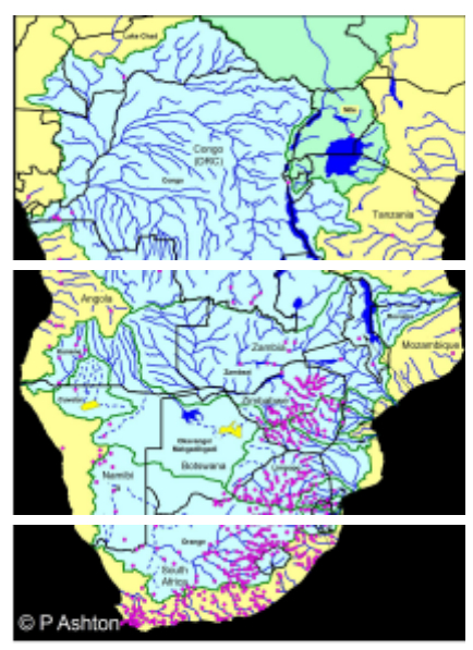
The flood-pulse in South African rivers has been lost to large dams (Source PJ Ashton, 2007). The uMzimkhulu is visible on the south-eastern coast as the only undammed river.
This factor has been repeated across all the economically significant rivers in the country. South Africa is listed among the top 20 countries of the world in terms of the number of large dams it has built. More importantly, rivers have been connected by means of major engineering interventions, known as inter-basin transfers. In effect then, the unique flood pulse of each river, has been reduced to a feeble flow of chemically altered water. This is most evident along the eastern seaboard, where almost every river, with a few exceptions, no longer flows into the ocean. In most cases, these east-flowing rivers now end in a lagoon, the flood pulse being too feeble to break through the sand banks on its own. Those lagoons are now the distil ends of a linear system, in which toxins and other pollutants have accumulated.
The uMzimkhulu River
The uMzimkhulu River is the last of the free-flowing rivers in South Africa of any economic significance. It can be placed on an ecological status similar to the Okavango for several key reasons. Both the Okavango and the uMzimkhulu Rivers are:
- devoid of hard infrastructure;
- retain a natural flood-pulse;
- sustain a large biodiversity downstream;
- examples of the intrinsic value of free-flowing rivers in terms of the livelihoods they sustain in ecotourism-related social activities;
- absolutely unique in the sense that their distil ends terminate in ecosystems that are fundamentally different from their hydrological sources.
In the case of the Okavango, the main biodiversity is found in the Delta, surrounded by desert, whereas in the uMzimkhulu River, the main biodiversity is found in the marine protected area centred on the Protea Banks. Both are unique in terms of the linkage they provide, across fundamentally different aquatic ecosystems. The Okavango starts in the well-watered Bie Plateau of Angola and terminates in a terrestrial desert ecosystem in which water is scarce. It consequently flows from an area of relative water abundance, to one of absolute scarcity. The uMzimkhulu starts in a relatively water scarce area (precipitation of around 700 mm/yr??) and flows into an area of relative water abundance (precipitation of around 900-1000 mm/yr??), but it terminates in a marine ecosystem where the nutrient flows provided by the natural flood-pulse play a unique ecological role driven by the pulsing of the saline wedge in the estuary.
Therefore, each are unique from an ecological perspective, and consequently deserving of a higher level of protection than “normal” rivers. This case becomes more compelling when considering the socioeconomic circumstances of the areas in which they are embedded, because both are characterised by the absence of industrial development and high levels of poverty. In both cases, the livelihoods arising from the rivers, when translated into ecotourism, is one of the biggest job creators in the local economy. The Okavango Delta is recognised as a world class ecotourism destination, whereas the Protea Banks Marine Protected Area is locally recognised, but with international significance, yet to be revealed to a global market. One of the unique features is the large population of breeding whales and gamefish, as well as the sardine run, which is a mass migration event on a scale similar to the wildebeest of the Serengeti as they cross the Masai-Mara.
There is certainly a convincing case to be made for the protection of the uMzimkhulu as the last of the free-flowing rivers in South Africa.
The uMzimkhulu estuary is an ecologically significant interface between the nutrient-rich freshwater flood-pulse of the river, and the saline water of the Indian Ocean.
Unlawful Development on the uMzimkhulu River
The future of the uMzimkhulu River is dependent on the unlawful activities that are threatening the ecological integrity of the system. It must be noted that the National Water Act of 1998 is the legal foundation for the management of rivers in South Africa. It is generally regarded by river management professionals as one of the best pieces of legislation in the world, ahead of its time in the way it gives the right of the aquatic ecosystem to its own water. This is known in legal jargon as “The Reserve”, of which there are two distinct components. The Basic Human Needs Reserve is the minimum flow that has to be left in the river to sustain human livelihoods, where no piped water is available to local communities. The Ecological Reserve is the water that needs to be left in the system to sustain the ecological activities that prevent the river from becoming an open sewer.
The Ecological Reserve is a complex value to calculate because it consists of the flood pulse – a volumetric value that is time-dependent – and a set of quality values such as temperature, pH, redox conditions and a host of elements that cover a large spectrum of the periodic table. A critical sub-set of the Ecological Reserve is the Estuarine Flow Requirement that is needed to sustain healthy ecological processes that only occur at the interface between fresh and saltwater. It is at this interface that many complex processes occur, because the seasonally-dependent flood-pulse, collides with the daily tidal pulse, in the estuary.
In the case of the uMzimkhulu River, this process has been disturbed by the dredging of sand from the river for purposes of concrete production. Section 21 of the National Water Act deals with any activity that alters the bed, bank or flow of a river in its area of jurisdiction. In all cases where alterations to the bed, bank or flow of a river occurs, regulatory intervention is mandatory. For some reason, this regulatory intervention has been successfully bypassed in the uMzimkhulu River, because industrial-scale sand mining has fundamentally altered the bed, bank and flow of the river. This has changed the complex interaction that occurs when the seasonal flood-pulse collides with the daily tidal-pulse.
The effect of this has been to drive a saline wedge up the estuary, for almost ten kilometres, where it has now placed at risk, the water supply to the entire population of the Ugu District Municipality. Authorities in the municipality, advised by consultants, are now considering a permanent concrete structure across the river at the Helens Rock Pump Station. Ironically, a major beneficiary of the concrete weir will be the very same sand mining operators that have created the need for the weir in the first place. Given the level of corruption that is known to exist in South Africa – no longer disputed since the Zondo Commission of Enquiry has laid the facts bare – there is a growing trust deficit between citizen and state. This is now mobilizing a concerted initiative by civil society to protect the last of the free-flowing rivers of South Africa, from the clutches of allegedly corrupt officials.
Industrial-scale sand mining, in contravention of Section 21 of the National Water Act, has placed the water supply of the Ugu District Municipality at risk, and triggered an attempt to build a permanent structure on the last of the free-flowing rivers in South Africa.
An exacerbating factor, in this case, has been the proliferation of unlawful abstraction upstream of the Helens Rock Pump Station, also in contravention of the National Water Act. The effect of this over-abstraction, in excess of authorised volumes, is most acutely felt at the end of the winter months when the first rains have not yet fallen, but market conditions dictate a premium for crops started early in the season. This means that the proposed weir is not necessary, provided that all activities altering the bed, bank or flow of the uMzimkhulu River, are regulated in accordance with the National Water Act.
Lessons from Melbourne Australia
An interesting lesson has been learned from Melbourne, in the state of Victoria, Australia. A strategic decision was taken by the executive authorities of Vic Water, the utility mandated to provide water security for the city, to decouple the water supply from the natural hydrological system. The decision was informed, somewhat progressively, by the science underpinning climate change. The technical consensus informing the decision was that climate change will increasingly place the water supply of the city at risk. This was articulated with the political leadership, and against all odds, buy-in was obtained. This enabled Vic Water to invest into seawater desalination at utility scale. This has created water security for the city, but with many benefits that were not initially anticipated. Among those benefits has been the inflow of capital, as investors feel confident about a local economy that is no longer subject to the unpredictable results of climate change, whether human-induced or not. For this reason, the city of Melbourne is awash with capital, and an economic windfall has resulted in high levels of employment and a lifestyle now considered to be one of the best in the world. But the greatest benefit has been to terrestrial aquatic ecosystems, because natural streamflow has been restored to many of the rivers that were heavily abstracted before the era of desalination. It is ironic that water can now be left in terrestrial ecosystems, as a direct result of the convergence of capital, technology and political will, simply by decoupling the local economy from the increasingly unpredictable vagaries of nature.
The Future of the uMzimkhulu River
Based on the assumption that Rule of Law can be restored in South Africa, and the requirements of the National Water Act will be implemented without fear or favour, we can conceivably expect the uMzimkhulu River to become the crucible of the transition from a linear to a circular economy. This requires political buy-in, but is certainly achievable, and has many benefits. The town of Port Shepstone, located at the estuary, is experiencing a rapid growth in demand for freshwater. Under present circumstances, water security can only be obtained from the uMzimkhulu River by fundamentally altering the flood-pulse of the last free-flowing river in South Africa. An off-channel storage dam is being planned, which will capture the flood-pulse, and supposedly make it available for human consumption. The consequence of this will be the loss of biodiversity in the Marine Protected Area that includes the Protea Banks. The opportunity cost of this altered flood-pulse will be the permanent loss of the job creation potential of a professionally articulated ecotourism sector in perpetuity. The current planning for the off-channel storage does not even consider this opportunity cost as being relevant. This is being countered by civil society, who believe that technological trends already demonstrated in South Africa, have clearly shown the viability of desalination at utility scale.
A recently completed technology demonstration, based in the city of Durban, has shown that blending treated sewage effluent into the incoming seawater, alters the salinity of the feedstock. This changes the economics of seawater desalination in a fundamental way, because the lifetime of a plant is in excess of thirty years, and the energy consumption over that period is significantly reduced by altering the osmotic pressure of the feedstock. This also changes the brine production, because less saline water logically produces less brine to be disposed of. This is known as the Remix Model, and it has demonstrated that the cost of desalinated seawater per unit over time, equals that of the surface water supply from conventional resources. Given that conventional surface water supply is under severe pressure, the cost of water from those sources will logically increase over time. This implies that desalination of seawater, at utility-scale, is both technically and economically viable.
https://www.youtube.com/watch?v=BIE9Lfuw10w
This viability is being improved as new technologies emerge. The Remix technology is but one of many. Another suite of technologies is driving the cost of energy down, as renewables are brought onstream. The problem with renewable energy – wind and solar – is that its peak availability is not naturally synchronised with peak demand. This is rapidly changing as hydrogen cells are being developed. This technology separates hydrogen from oxygen in water, by passing electricity through it. This enables peak energy from wind and solar, to now be stored in hydrogen. This can either be sold as a product of its own, with the revenues used to cross-subsidise the production of potable water; or it can be used to power the desalination process during peak demand. Desalination plant generally prefers to be operated as a steady state process, with few changes to the flow rate over time. This is now possible with the hybridization of desalination with the production of hydrogen. It is therefore feasible that the future water needs of Port Shepstone, estimated to be 108 megalitres per day, can easily be met from utility scale desalination, with the added benefit that the hydrogen economy can be pioneered in an area that is otherwise doomed to a future of economic stagnation. In this regard it can become truly transformative, just as the Melbourne case has demonstrated.
Conclusion
From a biodiversity perspective, the preservation of the natural flood-pulse in our rivers is of vital importance at the global level. In South Africa, the protection of our last free-flowing river is of great ecological importance, but it is equally of socioeconomic significance. The deeply impoverished area covered by the Ugu District Municipality, can be transformed by visionary leadership, because of the convergence of technologies that enable local economies to be decoupled from the hydrological circumstances in which they are otherwise trapped. The city of Melbourne is now the preferred destination of capital, even though its is as hydrologically insecure as Cape Town, both located in similar climatic conditions. The town of Port Shepstone is blessed with the presence of the last free-flowing river in South Africa of any economic significance, with a Marine Protected Area of international significance at its disposal for an ecotourism-based future. With visionary leadership, it can also become a pioneer in the transition from a carbon to a hydrogen economy. The technology to do this is readily available, and the capital needed is only waiting for bankable projects to be proposed, and a regulatory environment to be enforced. The upside of this is significant, not only in terms of biodiversity at the planetary scale but also in terms of the blueprint for a viable but sustainable socio-economic development trajectory.
“Thank you Professor Turton for taking the time to pen up this magnificent introduction to the complexities we face here on the mighty uMzimkhulu River and in South Africa as a whole as the ruling party turns the entire country into a toilet.” – Xona
Please consider subscribing to our weekly newsletter.
Thank you!

Dear Author. Your article is well written and a good read…Unfortunately, The umzimKhulu has a large Weir under the N3 Bridge. Grunter, Salmon and other esturine speicies cannot navigate up and past this point…
So your artcle is Flawed. The Umzimvubu which reaches the sea at Port St Johns is totally unrestricted. Both rivers start in the Lesotjo mountains near Matatiele, as the Umzinkhulu. I am not to sure where the split happens and becomes tje Umzimvubu
Hi Craig and thank you so much for your comment. Luckily we are right because I navigate up and past both the N3 and the low level, 19kms upriver. There is always enough water for me, my boats, and the fish to go all the way to the huge rapid just before the limeworks. I’d be so glad to take you…and then to understand the importance of the free flowing aspect of the Umzimkulu. Before they do build a dam or something stupid. 0793269671. Sean
Thank you Professor for pleading to save this free-flowing river. I‘m a documentary photographer coming from France to photograph the course of the Umzimkulu river in February 2024. I would be happy to get some local contact or insights from the communities along the river concerning traditional river usages, ecotourism, biodiversity, threats to the ecosystem etc.
Pease reach out and DM me on @photo_lebrun (Instagram) or by mail info(at)photo-lebrun.de